|
|
|
|
ABOUT ADIYAMAN (GENERAL) |
|
|
ADIYAMAN - ADMINISTRATIVE STRUCTURE AND HISTORY |
|
| Merkez | |
|
|
|
|
ABOUT ADIYAMAN (GENERAL) |
|
|
ADIYAMAN - ADMINISTRATIVE STRUCTURE AND HISTORY |
|
| Merkez | |
 Turkey
is divided into provinces, an administrative system barrowed from France. There
are 81 provinces (il) in Turkey. Each province is then subdivided into smaller
administrative units called ilçe (district), roughly
equivalent to a county in the U.S. Provinces are usually named after the biggest
city in that province. The two other large subdivisions are also named for the
biggest settlements in that division. Adıyaman is not only the largest city
in that province, it is also that provinces central district (ilçe).
Each İlçe is
subdivided into Bucak (like a township) and each bucak is further divided into
villages (köy). Adıyaman
has 9 districts (including the central one) and 12 bucaks
(townships).
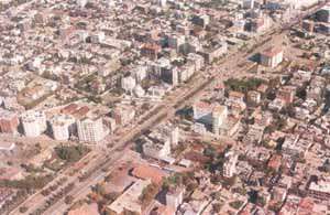
Central
District (The city of Adıyaman): According to 1990 census the population of the
central district of the province was 170,75 including bucaks and villages.
However due to recent migration, mostly caused by the displaced villagers due to
the Atatürk dam (part of Southeastern Anatolian project, called GAP), the population
is estimated to be over 200,000. GAP has accelerated the economic activity of
the city, especially in light industry.
HISTORY
Formerly HÜSNÜMANSUR, Arabic HISN MANSUR, city located in a valley
of southeastern Turkey. Founded in the 8th century by the Umayyad Arabs near the
site of ancient Perre, Hisn Mansur was later fortified by
Caliph Harun ar-Rashid and became the chief town of the
area, replacing Perre. Ruled successively by the Byzantines, Seljuq Turks, and
the Turkmen Dulkadir dynasty after the Arabs, it was incorporated into the
Ottoman Empire near the end of the 14th century. Under the Turkish republic, it
was renamed Adiyaman in 1926. The ruins of Perre are just to the north.
The city is a local market for the agricultural products of the area.
The region around Adiyaman contains mountains and plateaus drained by the Euphrates River and its tributaries. Products include cereals, cotton, tobacco, pistachio nuts, and grapes. Pop. (1990) 100,045.
Adiyaman is one of the oldest settlements in history, dating back to 40 th century B.C. Historical findings indicate that between 7.000 and 3000 B.C. Paleolithic, Neolithic and Chalcolithic Ages reigned in the area. It has been the host of many civilizations, including Hittite, Persian Kommagene, Roman and Byzantine. Founded at its present place, in thie 7 th century by the Ummayyads, Adiyaman later housed several empires and states, including Anatolian Seljuks and finally the Ottomans. In the republican era, Adiyaman had been a district of Malatya province until 1954. At that time it was given the status of province.
|
Chronology |
||
| From: | To: | Name: |
| B.C. 40,000 | B.C. 7,000 | Paleolithic |
| B.C. 7,000 | B.C. 5,000 | Neolithic |
| B.C. 5,000 | B.C. 3,000 | Kalkolithic |
| B.C. 3,000 | B.C. 1,200 | Hittites |
| B.C. 1,200 | B.C. 750 | Assyrians |
| B.C. 750 | B.C. 600 | Frigs |
| B.C. 600 | B.C. 334 | Persler |
| B.C. 334 | B.C. 69 | Macedonians |
| B.C. 69 | A.D. 72 | Kommagene Kingdom |
| A.D. 72 | A.D. 395 | Roman Imperial |
| 395 | 670 | Roman Imperial (Byzantines) |
| 670 | 758 | Emevis |
| 758 | 926 | Abbasiler |
| 926 | 958 | Hamdaniler |
| 958 | 1114 | Byzantines |
| 1114 | 1204 | Eyyubuler |
| 1204 | 1298 | Seljuk (Anatolian) |
| 1298 | 1516 | Memlukluler |
| 1516 | 1923 | Ottoman Imperial |
| 1923 | ---- | Turkish Republic |
GEOGRAPHY
Situated in Southeastern Turkey, Adiyaman Province is flanked by the provinces of Diyarbakir (to the East), Malatya (to the North), Kahramanmaras; (to the West), Sanlizurfa anda Gaziantep (to the South). Eight districts are attached to Adiyaman. The land is rough and uneven, lowering from north to south. Along with the famous Euphrates, there are other rivers and creeks flowing in and out of the province. A sizeable part of the province's land, with its people and settlements, bordering Euphrates, were left to the artificial lake of the Ataturk Dam. The overall population of Adiyaman is 5690.386, according to the 1997 Census. The city center houses more than 213.596 inhabitants.
GENERAL TRANSPORT
There are air, rail and overland routes to Adiyaman.
Golbasi district is the primary junction, on the main highway to
 Malatya,
Kahramanmaras and Gaziantep. Rail connections are also made in Golbasi, through
which Malatya - Adana railroad passes. The
Airport has opened in our city There have been flights from Adiyaman to Istanbul
via Ankara three times a week (Monday. Wednesday and Saturday)
CULTURE
Adiyaman has been the host of many civilizations throughout its history. Being a melting pot socially and culturally, it has valuable features related to customs about different periods of life, hospitality, folk dancing, carpets and kilims etc. Adiyaman is famous for its folk songs, folk dances and tombs (turbe). Different kinds of meatballs, such as "cigkofte, icli kofte, mercimekli kofte" and hitap (stuffed hot pie) are special local foods in Adiyaman.
Geography / Adiyaman Museum / Culture / Social / Economy / Health / Education / Tourism / Sport / Transportation / Municipalities / Where does the name come from? / Local Newspapers / Wildflowers / Wildlife /Adiyaman Forum / Adiyaman Portali
![]()
Home | Ana
Sayfa | All About Turkey | Turkiye
hakkindaki Hersey | Turkish Road Map
| Historical Places in Adiyaman | Historical
Places in Turkey | Mt.Nemrut | Slide
Shows | Related Links | Guest
Book | Disclaimer | Send a Postcard | Travelers' Stories | Donate a little to help
| Adiyaman Forum